

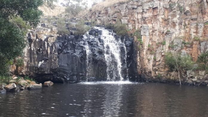
If you are looking for a walk that combines spectacular geology, a waterfall, a beautiful river valley and a little local art history, the Loddon Falls walk near Glenlyon is hard to beat. And after recent rains, the falls are at their spectacular best.
The walk begins at the Loddon Falls Reserve, about 5 km north of Glenlyon. It takes in the falls and gorge before continuing downstream along a quiet dirt track towards the broad river flats near the junction of the Loddon River and Kangaroo Creek. The return follows the same route.
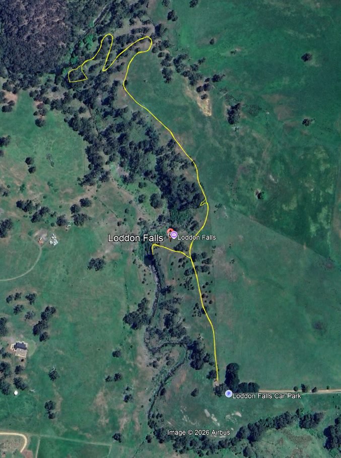
Start at the Loddon Falls car park at the end of Sewells Road. From the car park follow a dirt track north. The first section is easy, with views of the Loddon flowing over exposed basalt rock upstream of the falls. About 300m from the carpark, a path leads to the left. Take a minute to read the small interpretive sign about volcanoes and native flora and fauna at the beginning of the track. This is the only Parks infrastructure in the whole reserve. Follow the path about 100m to the escarpment above the falls.
The walk to the escarpment above the falls is easy (AWTGS grade 2) and the view from above is quite spectacular. The falls can be reached by a short steep, rocky descent into the gorge (AWTGS grade 3). Take care if you decide to descend to the falls, especially if the ground is wet.
Before heading down, take time to study the gorge from the top. The river has cut a spectacular narrow gorge with walls formed by enormous columns of dark basalt. A volcanic eruption about 2.5 million years ago covered the ancient riverbed of the Loddon. As the lava cooled and contracted, it developed the distinctive vertical cracks that created the hexagonal columns visible in the gorge. Over millions of years the river exploited weaknesses in the rock, cutting a new pathway through the basalt and creating the gorge.
In 1864 the Austrian-born landscape artist Eugene von Guérard visited Daylesford as a guest of W. E. Stanbridge during a six-week sketching expedition in central Victoria. He later painted four local landscapes including one commonly called “Loddon Falls” because that was the title in his sketch book but as you can plainly see, the painting pictured below does not resemble the falls that you have just visited. We need to explore a bit more to follow the footsteps of von Guérard.
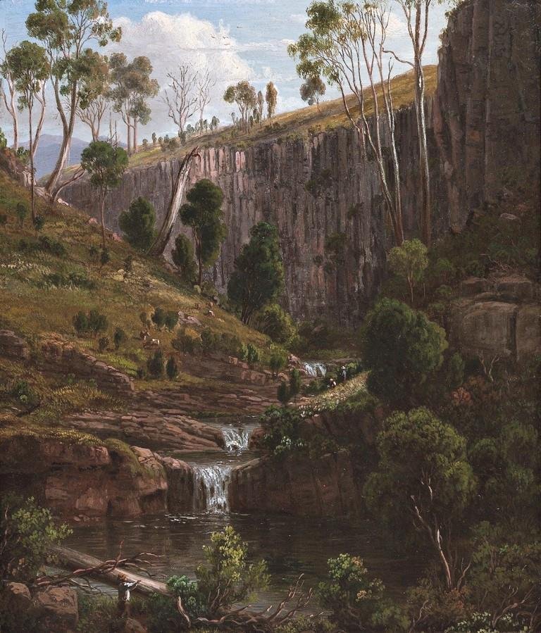
Return to to the dirt track along the top of the gorge. Instead of turning toward the carpark as most people do, turn left and continue along the dirt track. After about 80m, and before the road passes a fairly dense patch of forest, leave the track and walk about 10m through tall grass and scrub on your left. A view opens of a ravine with three distinct cascades, quite clearly the scene that von Guerard depicted. If you wander around a bit, you’ll find a place very close to where von Guérard sat as he sketched the ravine. The vegetation along the ravine is very similar if more dense that depicted by von Guerard and the grasslands to the west seem much as they were in 1864. The mountain depicted on the horizon on the left is clearly an expression of artistic license. The men and cattle in the foreground, typical of many von Guérard landscapes, are possibly an homage to his father who was a miniaturist.
Continue along the road at the top of the gorge. After about 800m, the road descends to broad river flats in the valley. When you reach the bottom, make your way to the river. There are no paths here and you will have to find your way through tall grass and scrub. Between the months of October and April, be particularly careful to watch for snakes. When you reach the river, walk upstream to a large pool that marks the junction of Kangaroo Creek and the Loddon. This is a particularly interesting part of the walk. When the volcanic lava flow covered the ancient waterways, the Loddon carved a new path through the basalt of the lava flow, but Kangaroo Creek found a new path around the leading edge of the flow. To the south of Kangaroo Creek, on your left, volcanic soils support dense grass and and a lush understory, with towering white gums (Eucalyptus dalrympleana) and wattles. On the north side of the Creek, the ancient, depleted soils support very little understory and a forest of mostly peppermint and box. The contrast in vegetation on opposite sides of the creek is quite striking.
If you make your way east, away from the river and toward the steep embankment, you will find the remains of a dam wall and a water race leading from the south, a legacy of the gold rush years when the Loddon was explored for alluvial gold.
The flats along the river make a pleasant place for a refreshment break or a picnic lunch before you start the return journey. To return to the carpark, retrace your steps. Take time to admire the ancient river red gums and views of the valley on your way back.
Walk Summary
Start: Loddon Falls Car Park, Glenlyon
Distance: 3.5km
Elevation gain: 90m
Time: 1.5 hours plus stops
AWTGS Rating: Grade 2 for the main walk; Grade 3 for the descent to the falls.
GPX file: Loddon-Falls-Walk.gpx
Mobile coverage: Good mobile coverage for most of the walk except deep in the gorge.
Amenities: None on the route. Nearest public toilets are at Glenlyon Recreation Reserve.
Conditions: The track is in reasonable condition at the time of publication. There are some large puddles due to recent rains but these can be avoided.
Safety Information
This walk description is provided for general information only and is accurate at the time of publication.
Assess your own fitness and that of your group and take responsibility for your safety. Carry water and food, and take a mobile phone, map, compass and first-aid kit. Wear sturdy footwear and appropriate clothing for the conditions.
The descent into the gorge is steep and rocky, with no safety barriers. Take particular care on wet rock and keep children away from the cliff edges. The basalt columns are unstable in places, so do not climb on the cliff faces or approach unstable rock.
Weather conditions can change quickly. Check the Bureau of Meteorology forecast before setting out and consult the CFA website for fire danger ratings. Do not walk on days of Extreme or Catastrophic fire danger or when the predicted maximum temperature is 35°C or higher.
Tim Bach is the President of the Great Dividing Trail Association and a member of The Wombat Post editorial Committee.