

If you are looking for a walk that combines pleasant bushwalking with stark reminders of the environmental impact of the gold rush, the Beehive Gully circuit from Hepburn Springs is well worth exploring. This 12.3 km circuit is more challenging than previous bushwalks in this series. It follows a section of the Goldfields Track through Hepburn Regional Park, past the remarkable mining erosion landscape in Beehive Gully, the historic Hunt’s Dam and finishes along a 1.2km section of the Argyle Springs walk recently enhanced with interpretive signage and sculptures by local Dja Dja Wurrung artists. The Chocolate Mill offers an opportunity for refreshments at the halfway point and might prove an inducement for children or grandchildren who you’re trying to encourage to enjoy local bushwalking.
Although we’ve had a wet winter, the track condition is good for the entire length. The track is rugged in places and there are a number of steep climbs so the AWTGS rating is Grade 3. The forest is full of wildflowers now – watch for tetratheca, hardenbergia, and various wattles and pea flowers.

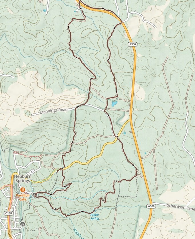
The walk begins at the eastern end of the Hepburn Springs Reserve car park, at the Goldfields Track entry station. For the first 6km of the walk, you will be following the yellow topped Goldfields Track marker posts. About 1.2km from the start, you will reach Back Hepburn Road. A short side track to the left leads to Jackson’s Lookout which provides panoramic views of the surrounding bush and nearby hills.
Return to the main track, carefully cross Back Hepburn Road and follow the track about 400m to Woman’s Gully. From there the track climbs steeply before dropping into Widow’s Gully. Another climb brings you to Mannings Road. Follow Mannings Rd to the right for 150m until the Track turns left back into to the forest.
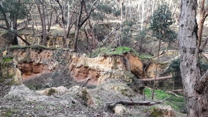
The character of the walk changes dramatically as the track drops towards Beehive Gully. Here the destruction of the nineteenth-century mining operations becomes apparent. The gully has been deeply eroded to resemble a miniature canyon. When they had exhausted gold in the creek bed, miners used pressure hoses to wash the banks of the creek. In Beehive Gully, these sluicing operations stripped away the surface and exposed the underlying material from which additional small amounts of gold were obtained. However, the discarded dirt wash resulted in enormous quantities of sludge which was carried downstream eventually in this case to the Loddon River. The problem became so serious in this and other Victorian Rivers that the state government passed the Sludge Act in 1910 to regulate mining and reduce the environmental impacts.
After following the gully for about a kilometre, the track emerges near the Midland Highway and the Chocolate Mill. This is a great spot for refreshments but make sure you time your walk to arrive between 10am and 4pm when the café is open. The return part of the walk is slightly longer (7km) so you might also take the opportunity to stock up on essentials in the Chocolate Mill shop.
After your break, carefully cross the Midland Highway at the the Goldfields Track marker post to enter the bush on the other side. Turn right and follow the track alongside the highway for 1km to “Letterbox Corner”. Leave the Goldfields Track, turn right and carefully cross the Midland Highway once again to a four-wheel-drive track in a small cutting. Continue for about 1.5km to reach Hunt’s Dam. When the dam comes in sight, an optional small track leads down to the dam and reconnects with the main road further along.
Hunt’s Dam provides an interesting counterpoint to the sluice mining damage at Beehive Gully because this dam was part of the infrastructure that enable the gold workings in the first place. The dam was part of an extensive network of water races constructed to bring water to the Dry Diggings where there were gold deposits but little water to wash the dirt. Mr Hunt was one of many locals who sought a more assured income by selling miners what they needed rather than taking his chances on mining for himself. He built a 24km water race from this dam to the Dry Diggings area along Middleton Creek thinking he would be able to sell water to the miners for years to come. Unfortunately for Mr Hunt, the miners exhausted the diggings in little over a year and Mr Hunt’s superannuation project left him penniless.
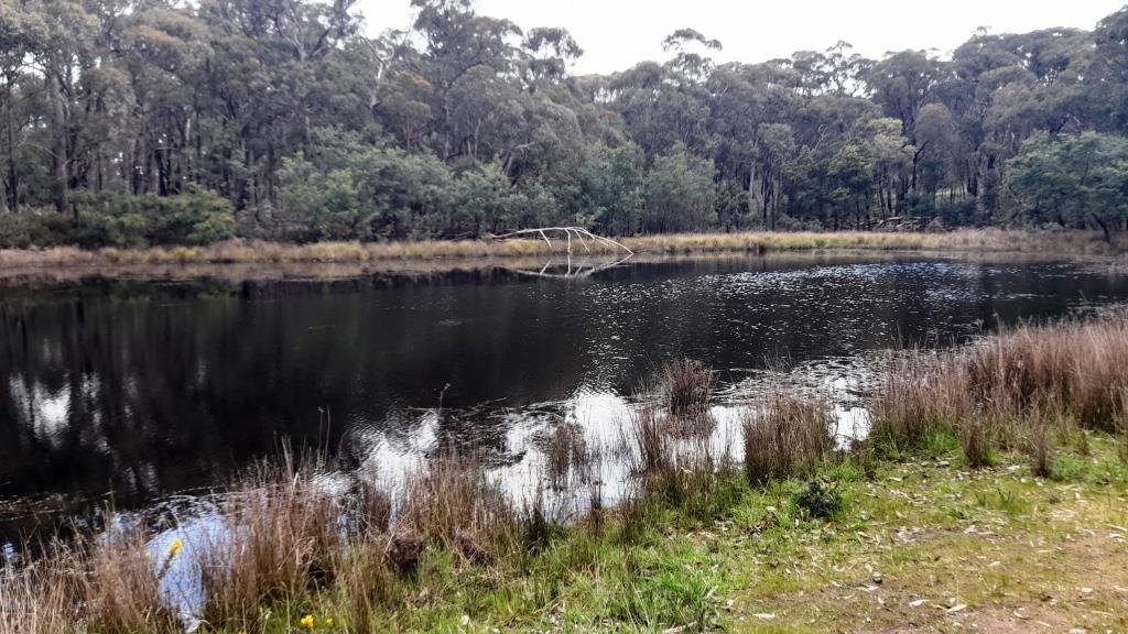
Keep left just past the dam and after another 300m you will reach Mannings Rd. Turn left into Mannings Road and continue for about 500m to Back Hepburn Road, Cross to the right and pick up another bush track on the left near a “Womindjika” sign. Follow the track for 800m to a four-way intersection. Take the main road to the right for 700m. At a blue-topped post, a small track leads to the left. Follow this down a steep, winding track to Argyle Spring.
The last part of the walk is along a narrow walking path beside scenic Wildcat Creek on the recently upgraded Argyle Spring Walk, which leads from the spring towards the Hepburn Mineral Springs Reserve. This part of the walk incorporates Dja Dja Wurrung art and interpretive signage as part of a cultural trail called Nyerna Djayi Wurreka, meaning “listening to Country speak”. The trail has eight “pause points” with seating that encourages walkers to stop rather than simply pass through the landscape. From Argyle Spring, follow Wild Cat Creek downstream for about 1.2km passing Wyuna Spring to return to the Hepburn Springs Reserve.
The forest may have reclaimed much of the goldfield, but the scars left by the miners remain remarkably clear. Beehive Gully shows the physical consequences of sluicing, while Hunt’s Dam and its race show the engineering infrastructure required to supply the enormous quantities of water that made such mining possible. The final section at Argyle Spring adds another perspective, connecting with the continuing culture and knowledge of the Dja Dja Wurrung people.

Walk Summary
Start: Hepburn Springs Reserve, eastern end car park
Distance: 12.3 km
AWTGS Rating: Grade 3 (medium), with rough tracks and some steep climbs
Time: Allow about 4 hours plus stops
GPX file: Beehive Gully GPX
Amenities: Toilets are available at Hepburn Springs Reserve and for customers at the Chocolate Mill when open.
Track conditions: The route includes forest tracks, four-wheel-drive tracks, road walking and some rough sections. Take particular care when crossing the Midland Highway and other roads.
Safety Information
This walk description is provided for general information only and conditions can change. Assess your own fitness and that of your group before setting out. Carry adequate water and food for a day walk, and take a mobile phone, map, compass and first-aid kit. Wear sturdy footwear and appropriate clothing for the conditions.
Some sections are steep and the tracks can become slippery or muddy after rain. The deeply eroded sides of Beehive Gully are unstable in places, so stay on the marked route and do not attempt to climb the erosion pillars. Check the weather and fire danger rating before setting out and avoid walking on days of Extreme or Catastrophic fire danger.
Related stories
Take a Hike: Loddon Falls
Take a Hike: Lake Daylesford and Jubilee Lake
Tim Bach is the President of the Great Dividing Trail Association (GDTA) and a member of The Wombat Post editorial committee. The walk described here is based on Walk 5 in the “Central Victorian Highlands Walk and Ride Circuits” booklet available from the GDTA website or from Paradise Books in Daylesford.