If you’re looking for something to do over the weekend to get you out of doors, look no further than the Two Lakes Walk that takes in Lake Daylesford and Jubilee Lake. This easy 9 km circuit combines urban walking with bush tracks and highlights the beauty of these local gems. A map of the route can be downloaded from the Great Dividing Trail Association website. There is plenty of interpretive signage along the way so take a bit of extra time to connect to the landscape.
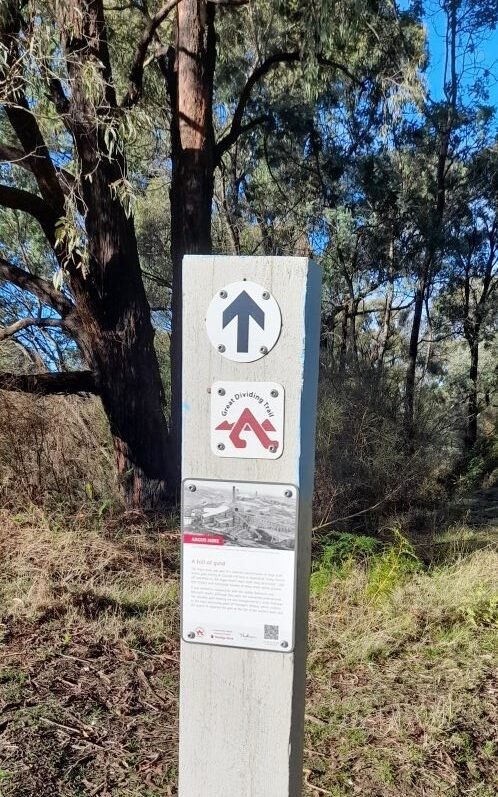
Start at the Lake Daylesford lookout in Bridport Street where there is usually plenty of parking. (Note that this is a slightly different starting point than that shown in the map.) You are at the start of the Lerderderg Track, an 80+ km shared use walking and mountain biking track that leads from Daylesford to Blackwood and on to Bacchus Marsh. A trail entry sign near the lookout provides more information.
From the lookout walk south and follow the road around to the left into Ruthven Street for about 100m to Vincent Street. Turn left for 100m and then right into Stanbridge Street. Walk uphill about 150m past the skate park and turn right into Argus Street until it meets Orford St. Turn right for 50m to reach the Thomas Lookout where there are expansive views of Daylesford to the north and west. The lookout is built atop the mullock heap left by the Cornish Hill mine. Over $250 million worth of gold (in today’s currency) was taken from the mine during its 60 year life.
Continue south as Orford St turns into a dirt track through Cornish Hill where you will eventually meet the blue-topped trail posts marking the Lerderderg Track. Follow the Lerderderg Track markers to the now covered Argus mineshaft site which descends 300m (1000 feet). To your left is what appears to be a small mullock heap, much smaller than might be expected for such a deep shaft, but a short walk to the top of the heap reveals how far it descends into the valley to the north. The mine closed almost 100 years ago, and little vegetation has established on the discarded rubble.
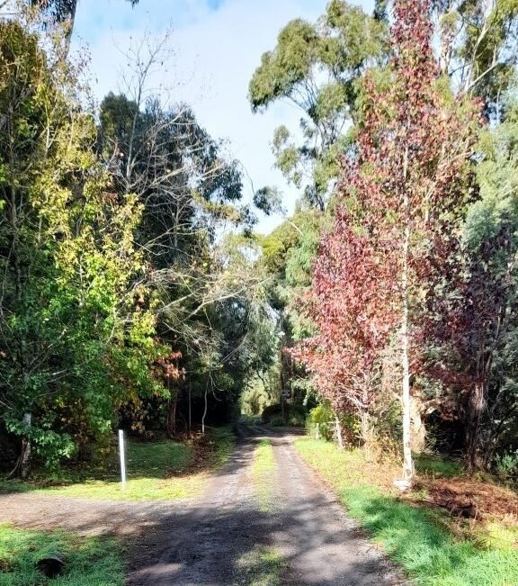
Continue south along the track through Cornish Hill Reserve, across Smiths Creek still following the Lerderderg Track posts until you cross an unmarked road (Patterson Street) and enter Italian Hill. You are now following the alignment of the former Daylesford–Creswick railway line, opened to great fanfare in 1886.
In the late 19th century, before motor vehicles, railways played a crucial role in the economic growth of Victoria’s regional towns. They provided a relatively fast and inexpensive means of transporting goods and people between Melbourne and regional centres. Soon after Daylesford was connected to the Bendigo line at Carlsruhe in 1880, residents began advocating for a link to Creswick, enabling travel to Ballarat via the Maryborough line. When the line finally opened in 1886, such was the excitement that a public holiday was declared.
The route here is fairly straight and even, although the cutting near Jubilee Lake can become very wet after heavy winter rains.
As the rail trail approaches Jubilee Lake, you will encounter a substantial timber trestle bridge crossing the dam wall. Although now used as a footbridge, it once carried the trains between Daylesford and Creswick.
Before the trestle bridge, turn left and follow a well-trodden path around the perimeter of Jubilee Lake. Originally constructed in 1860 as the Hepburn Goldfields Reservoir to supply water to nearby mines, it was renamed Jubilee Lake in 1887 in honour of Queen Victoria’s Golden Jubilee.
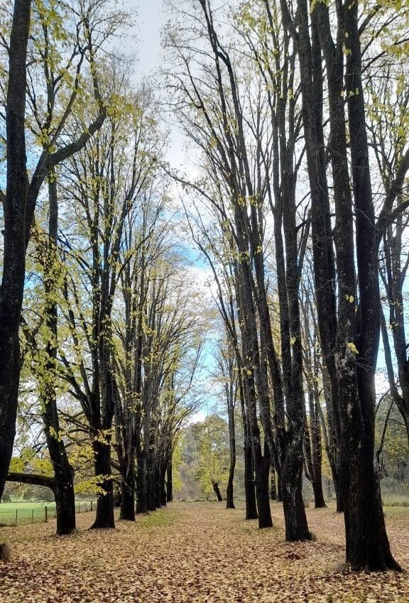
Continue around the lake to a timber bridge. Once across the bridge you have the option turning left for a 200m side trip to the Jubilee Lake Mineral Spring and back to the bridge. Continue along the south shore of the lake through a cathedral-like grove of mature elm trees. In autumn, the golden foliage and fallen leaves create a striking scene.
Follow the shore to the campground kiosk, a good place to stop for coffee or a hot chocolate. Public toilets are located nearby across the car park.
Continue around the lake until you return to the trestle bridge. Pop up the short track on the right to a rotunda built by the GDTA as a place to rest or shelter from the elements. Return to the trestle bridge but instead of climbing back up to the railway cutting, turn left and follow a path that contours back toward the town below the railway cutting. You are on an old water race that once carried water from the dam to local gold diggings. The path contours above Wombat Creek for about 800m before descending to Lake Road.
Turn left at Lake Road for about 30m to cross a small bridge, then turn right to follow the creek downstream. Although it may look like you are entering private property, stay between the creek and the pittosporum hedge as the grassy verge gradually becomes a dirt road. Cross a small footbridge and continue west uphill avoiding other roads to the left or right for about 500m until you reach Ballan-Daylesford Road.
Cross the road and turn right to walk in the shade of the huge pine trees along the boundary of Victoria Park. Turn left into Burrall Street for about 500m and then veer right as it becomes Leggatt Street. Cross Old Ballarat Road and continue into Chatfield Avenue following it downhill past a maintenance gate to Lake Daylesford.
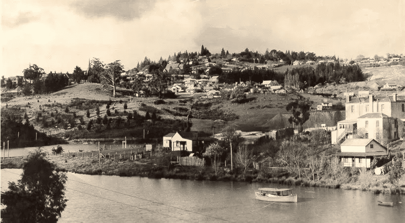
Lake Daylesford was once the Wombat Creek valley and was the site of extensive alluvial mining in the gold rush years of the 1850s. It was home to a Chinese settlement and market gardens supplying fresh produce to the town. The surrounding landscape had been completely cleared of trees and littered with the detritus of mining operations.
In 1929, a dam was constructed to create the lake, submerging the Chinese settlement, market gardens, and a Joss house. The project aimed to beautify the scarred landscape and enhance Daylesford’s reputation as a spa destination. While some mineral springs were lost beneath the lake, several remain in Central Springs Reserve below the dam wall.
American architect Walter Burley Griffin advised on the landscaping the lake, recommending native vegetation along the western shore. Local groups, including the Progress Association and schoolchildren, helped plant both European and native trees, a tradition continued since the 1980s by the Friends of Lake Daylesford (FOLD).
Turn left across the dam wall and follow the footpath around the lake. You soon come to a small amphitheatre just before the path climbs quite steeply. This amphitheatre was the quarry that supplied the rock to build the dam wall. In earlier decades, the bleachers here and on the opposite of the lake accommodated spectators for swimming and diving competitions, including Victorian country titles.
Continue around Lake Daylesford for about 800m. Just before you reach the second of two small landings on the lake a Goldfields Track directional sign points to a paved path which winds up the hill to the starting point at the Bridport Street Lookout.
You should be feeling relaxed after your walk but perhaps in need of some refreshment. Vincent Street is only two blocks away with its myriad coffee shops and cafés. Reward yourself with a coffee and a pastry or settle in for lunch with a glass of wine. You deserve it.
A similar circuit walk is featured in the recently published Lerderderg Track Walk or Ride Guide, by the Great Dividing Trail Association. The guide is available from the Daylesford Visitor Information Centre, Paradise Books, or the GDTA website.
Walk Summary
Daylesford Two Lakes Circuit Walk
Distance: 9 km
Elevation Gain: 140m
AWTGS Rating: Grade 2
Map: GDTA Daylesford Circuit Walk
Mobile Coverage: Reception available over the entire walk
Amenities: Jubilee Lake
Condition: At the time of publication (June 12, 2026), the track is in good condition. There are a few trees down in Cornish Hill but they do not block the track. Due to recent rain, the track is wet and muddy in the railway cutting near Jubilee Lake.
Safety Information
This walk description is provided for general information only and is accurate at the time of publication.
Assess your own fitness and that of your group and take responsibility for your safety.
Carry sufficient water and food for a half-day walk. Take a mobile phone, map, compass and first aid kit. Wear sturdy footwear and appropriate clothing for the conditions.
Walkers should check the Bureau of Meteorology forecast for Daylesford and consult the CFA website for fire danger ratings. Do not walk on days of Extreme or Catastrophic fire danger or when the predicted maximum temperature is 35°C or higher. Weather conditions can change quickly so be prepared.
Tim Bach is the President of the Great Dividing Trail Association and a member of the Editorial Committee of The Wombat Post.