There has been further damage to walking tracks around the district.
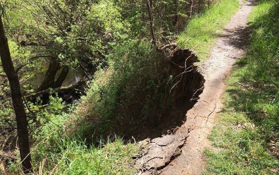
A land slip on the Twin Bridges track from Lake Daylesford to the bridges on the south side has resulted in closure of the track. The northern circuit of the track is still accessible. The land slip was probably a result of continuing wet weather which has brought much higher than normal rainfall to the area.
As the weather warms and Melbourne exits lockdown, walking tracks will be popular with locals and visitors alike. An update on local trail conditions is timely.

Fallen trees have closed the Domino Track between Trentham and Lyonville.
The popular Domino Trail between Trentham and Lyonville is still closed due to the storm event in June. The trail was heavily impacted by fallen and hanging trees and is dangerous for people utilising the trail. Accessing the trail to clear the trees is challenging currently with wet ground conditions. Council staff are monitoring the situation and are hoping to commence clearance works in the coming months.
The popular Two Lakes walk from Lake Daylesford to Jubilee Lake is open although the old railway cutting between Italian Hill and Jubilee Lake has some trees down and is very soggy underfoot. A marked diversion from the railway cutting just south of Italian Hill to the bridle path below the cutting makes the circuit to and from Jubilee Lake more easily accessible.
The northern section of Hepburn Regional Park has reopened but the Park section to the west of Daylesford still has a number of road closures. Parks and Forest Fire Management Victoria have been focussing on vehicle access tracks in preparation for the summer season. Walking tracks are a lower priority.
The Great Dividing Trail – Lerderderg Track is closed south of Jubilee Lake through to Blackwood and the GDT – Wallaby Track is closed south of Telegraph Road through to Mollongghip. The Lerderderg Heritage River Walk at Blackwood is also closed.
The Great Dividing Trail Association has a page on their website which provides updates on the condition of circuit tracks in their new Central Victorian Highlands Walk and Ride Circuits booklet. The booklet is available from the GDTA website or from the Daylesford Regional Visitor Information Centre.
Forest Fire Management Victoria has a map page which shows most current road closures. Click on the “More to Explore” icon to load an overlay of road and trail closures. (Caution: Because of a bug which FFM are currently trying to resolve, the map does not show Public Safety Zones (areas closed to the public) and there may be road closures not shown. Pay attention to signage.)


